Kasol-Kheerganga-Tosh-Malana-Trek
Speak to our expert Trek Advisors to help you choose the right trek.
Have Questions About This Trek?
Send us your enquiry and we'll get back to you soon.
About This Trek
For the wanderers by soul and adventurous by heart, the heavenly state of Himachal Pradesh comes as a gift from God. All you need is a backpack on your shoulder and an indomitable spirit to explore the unknown in your mind, and you can conquer the enchanting values that lie within the chains of mountains in this part of the Himalayas. One such is the beautiful Parvati Valley, birthing from the confluence of Rivers Parvati and Beas in the Kullu district of Himachal.
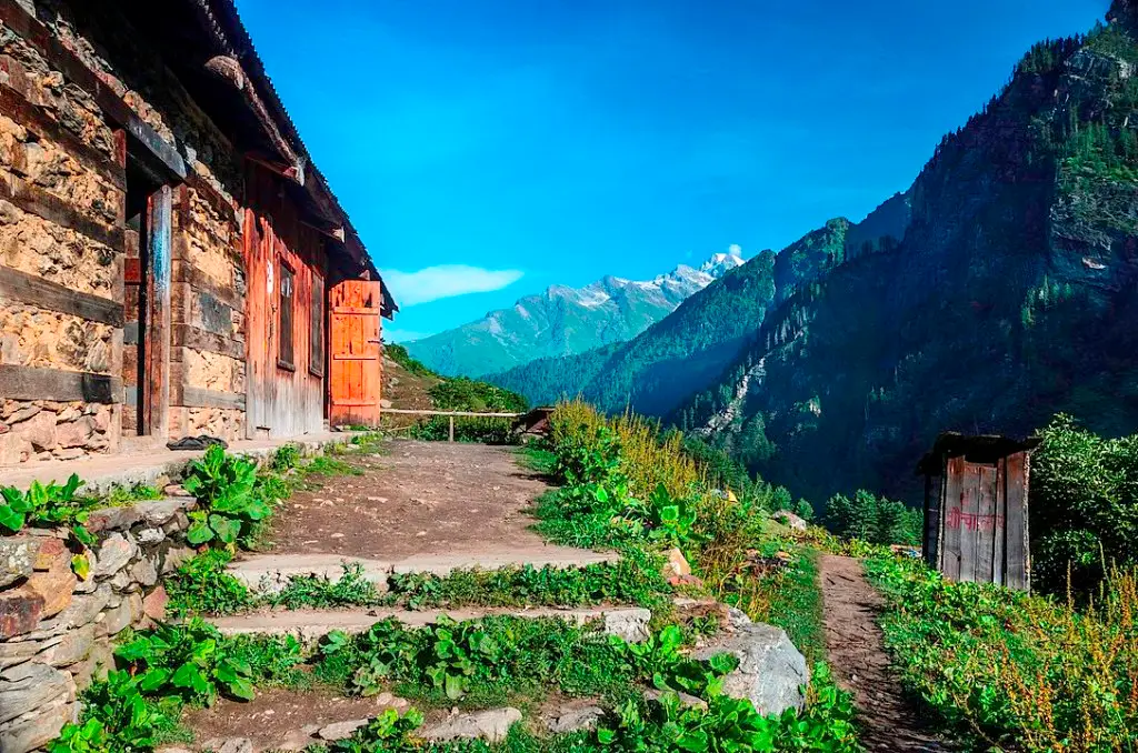
With all its charm and beauty, Parvati Valley lures out thousands of trekkers and travellers every year to its pristine lands, who answer unfailingly to the call of the mountains. Lush green runs along the two banks of the river up the mountain slopes; and higher up there are vast stretches of snow, running right up to the delightful crowns of the majestic peaks. Amidst this brilliant display of nature at its best, there are a bunch of villages with residential huts and tiny little shops scattered sporadically.
Kasol is one such pretty-as-a-picture hamlet, located between Bhuntar and Manikaran. This quaint village is growing in popularity among trekkers and backpackers, but its beauty is still virgin and untarnished enough to give you an enigmatic ambience. The unique thing about Kasol is its globalism amidst localism. You will find people from different ethnicities and far corners of the world settled here, drawn by the appeal of nature. Israelis are in large numbers, and you will spot several restaurants and cafes with Israeli food and Hebrew banners. From Kasol, one can set off for a trek to Kheerganga or take a hike to Malana.
Kheerganga, while being a spiritual site owing to the legend of Lord Shiva, has a sensational beauty of its own. The entire area is a sprawling stretch of green pastures, occasionally interrupted by gurgling hot springs and local huts and cafes.
Tosh lies between Kasol and Kheerganga, tucked between high cliffs and tall conifers. The location largely caters to Bohemian-style travellers, who were known as ‘hippies’ in the 1960s and 70s. The village is indeed a melting pot of the kind of people who live off backpacks for months and never like to know what adventure awaits them the next day.
Malana, on the other hand, is more of a secluded, laid-back village on a side valley by the ferocious River Malana, overshadowed by the peaks of Chanderkhani and Deo Tibba. Malana is different from all other villages in the Valley or even in the entire state. The residents of Malana are known for having their separate lifestyle, culture and language than the rest, and even different legislation.
About Kasol-Kheerganga-Tosh-Malana Trek
- Region: Himachal Himalayas
- Highest elevation: 13,051 ft or 3,977 metres (Kheerganga)
- Difficulty: Easy
- Duration: 4 nights 5 days
- Route: Kasol – Tosh – Kheerganga – Malana – Kasol
- Total distance covered: Kasol to Kheerganga via Tosh – around 30 km, Kasol to Malana – 21.5 km
- Start point: Kasol
- End point: Kasol
- Base Camp: Kasol
- Lodging: Hostels/Homestay/Camp tent
- Weather: The average daytime temperature during summer is 8 degrees to 20 degrees Celsius during summer and at night it goes down to 2 degrees to 10 degrees. In winter, it gets much chillier with regular sub-zero temperatures to be expected. However, snowfall is not that treacherous here and the region can be trekked any time of the year. You will just need to have a higher tolerance to cold.
- Nearest airport: Bhuntar
- Nearest railway station: Joginder Nagar
- Last ATM: Kasol and Manikaran
The trek will start from the base at Kasol and take you along a beautiful journey through charming forests of pine, nestling valleys, sparkling streams of the river and cosy camps under a gorgeous blue sky. From Kasol, you will first visit Tosh and then trek to Kheerganga via Rudranag temple. On your way back, stop at Kasol again for rest and a meal, and then visit the village of Malana. Within this short itinerary, you will hopefully have a remarkable experience with us which will be worth remembering forever.
How to reach the Kasol
Kasol will be the first stop of the 4-day trek, which can be reached via Bhuntar if you take public transportation or directly in a hired cab. You have to reach Kasol on your own, so you can avail of any of the following modes of transport.
- Roadways
- Airport
- Railways
Travelling by road is the most common practice to reach Bhuntar. You have to start from Delhi, which is 481 km away and takes nearly 12 hours, or from Chandigarh, which is 240 km away and takes 7 hours. If you hire a cab, then you can arrive right at Kasol without having to stop at Bhuntar. You can also stop at the roadside Dhabas at your will to enjoy meals and tea breaks along the journey.
But in the case of public transportation, which is cheaper, Bhuntar will be your first stop. There are both private and HRTC Volvo buses leaving from ISBT bus stops in Delhi (Kashmir Gate) and Chandigarh. The Volvos leave in the evening from Delhi and late at night from Chandigarh, so the travellers can reach Bhuntar at around 6-7 AM the next morning. From Bhuntar, there are local bus routes that pass via Kasol to Manikaran Sahib or Barshaini. Hop onto one of these buses to reach Kasol which is the base camp for your trek.
Bhuntar has an airport which is 31 km away from Kasol, but it has limited connectivity and expensive flights with long durations. If you are coming from another part of the country and want to travel by airway exclusively, then it would be wise to land at Delhi or Chandigarh and then take another flight to Bhuntar.
The nearest major railhead is at Pathankot, but it is 150 km away from Kasol. Joginder Nagar railway station is closer in distance, 124 km away. From both the places you can get cabs for Kasol.
Best Time to Visit
The best time for this trek is during September to November when the weather is pleasant and the views are clear.
Trek Details
Start Point
Kasol
End Point
Kasol
Pickup Location
Kasol
Drop Location
Kasol
Health & Safety
- For any Himalayan Trek, Ideal BMI for a trekker should be 18.5 to 24.9
- To keep a check of this please calculate BMI here
- Below given Safety checks should be done to get prepared for any Himalayan Trek.
- Balance : As well said a balanced mind and body gives out best in every condition and that too works in Himalayan treks as well.
- Legs Strength : Body and Legs Strength is required to carry body weight as well as the backpack while trekking in uneven multi terrains. Generally, a good strength on legs works out good in any Trek. One can gain legs strength by doing simple Squats.
- Muscle Flexibility : While trekking in Trans Himalayan region with a flexible body one can easily achieve full range of movement and this can be really helpful for trekkers as well as trek leads. A good flexible will be an advantage while walking on trails, climbing and river crossing etc. Flexibility can be achieved by simple stretching, yoga etc.
- Cardiovascular Endurance : Cardiovascular endurance is defined as the ability of lungs and heart to transmit oxygen to the body muscles. All Himalayan treks are basically ascending descending the slopes and for this trekkers should be having a good cardiovascular endurance. Anyone planning for a Himalayan trek can attain this capacity by doing any cardio exercise like running, swimming, cycling etc.
Speak to our expert Trek Advisors to help you choose the right trek.
Have Questions About This Trek?
Send us your enquiry and we'll get back to you soon.
Have Questions?
Speak to our expert Trek Advisors to help you choose the right trek.