Experience the Kuari Pass with
Moxtain
Kuari Pass
Speak to our expert Trek Advisors to help you choose the right trek.
Have Questions About This Trek?
Send us your enquiry and we'll get back to you soon.
Trek
Kuari Pass Trek
Difficulty Level
Easy to Moderate
Ideal for Beginners.
Duration
6 Days / 5 Nights
Max Altitude
12,763 ft (3,890 m)
Base Camp
Joshimath/Lower Auli
Best Time to Visit
Dec to March
Best for a snow experience (Dec–Mar)
About This Trek
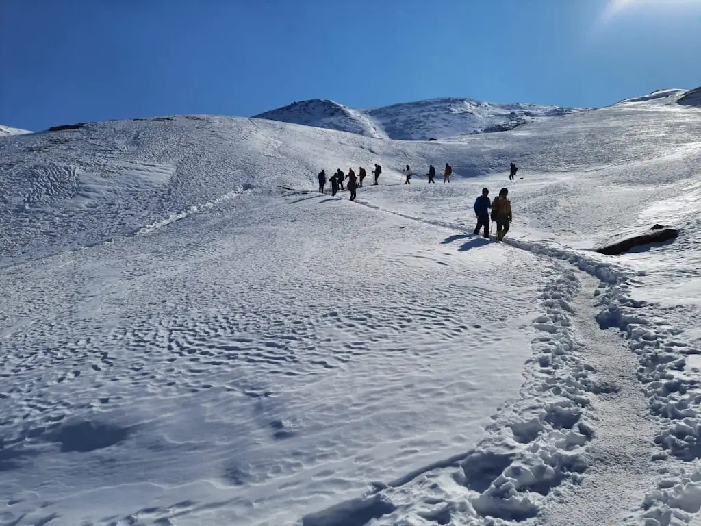
Kuari Pass trek is one of the most magnificent treks in Uttarakhand to explore, located in the heart of the Garhwal Himalayas. The trek is also known as Lord Curzon’s Trails because it was Lord Curzon who happened to discover this Kuari pass trek route, situated at around 3,800 meters (12,500 feet).
For those who enjoy hiking, the Kuari Pass Trek promises an amazing experience. This journey, which is well-known for its breathtaking views and varied landscapes, offers an amazing perspective of some of the highest peaks in the Indian Himalayas, including Nanda Devi, which is the country's second-highest peak.
Along with being a visual feast, the path provides a wealth of cultural experiences, including the chance to engage with and learn about the customs of the nearby Garhwali community.
- Difficulty- Easy-Moderate
- Duration- 6 Days
- Maximum Altitude- 12,763 ft
- Pickup point - Rishikesh/Haridwar
- Base Camp- Joshimath/Lower Auli
- Minimum Age to opt for Kuari Pass Trek- 8 Years
- Best time to visit- Mid-September to Mid December
- Nearest Railway Station- Rishikesh Junction
- Nearest Airport- Jolly Grant Airport
- Start Point- Rishikesh
- End point- Rishikesh
Trek Details
- Pickup Point on Day 1- Natraj Chowk or Tapovan, Rishikesh
- Departure time on Day 1- 6 am
- Drop Point on Day 6- Natraj Chowk or Tapovan, Rishikesh
- Arrival time on Day 6 - 6 pm
- Base Camp- Joshimath/Lower Auli
- Distance from Rishikesh to Basecamp, Joshimath- 260 km
- Cloakroom: There is no separate cloakroom available. You can hand over your luggage to our team and collect it while returning. We keep it safely at Joshimath/Lower Auli in the same Homestay.
- The shared vehicle will be a Tata Sumo, Bolero, or a similar kind and may be shared with a few other local passengers. The cab will be arranged from Rishikesh to Joshimath/Lower Auli and back.
- We charge Rs.1200/- per person on each side per person.
- The cab is a 7-seater.
- The whole journey by cab costs 7500/- from Rishikesh.
- Trekkers may choose to travel by bus or local cab to reach Joshimath/Lower Auli.
- The forest permits for international clients will be as actual and are to be paid by the trekker at the base camp only.
How to Reach Kuari Pass?
Kuari Pass Trek has a very well-established connectivity with the important towns of Uttarakhand which makes it very easily accessible.
By Air:-
The airport that’s accessible in Dehradun is Jolly Grant Airport. It is located at a distance of 43 km from Haridwar. The airport is at a distance of 204 km from Joshimath.
There are flights operational from Delhi to Dehradun daily which makes the journey very flexible. If opting for a flight, try reaching one day prior.
By Train:-
Haridwar has a well-established rail network that connects it to the major cities of the country like Delhi, Mumbai, and Lucknow to name a few.
- From Delhi- DDN NZM AC EXPRESS (2205)
- From Kolkata- Doon Express (13009)
- From Mumbai- Dehradun Express (19019)
- From Chennai- Dehradun Express (12687)
By Bus:-
Haridwar bus stand has connectivity with all the important towns across the country. Direct buses are available from the bus stands of different towns. Both government buses and private buses are available thus providing ample options.
If you are travelling from Dehradun then buses are available from Dehradun also.
Dehradun to Joshimath direct buses are available from Mussorie Bus Station around 5:30 a.m.
Another option available is :-
- Dehradun-Gopeshwar- Mandal- Chamoli.
If one wants to travel from Rishikesh then Rishikesh to Joshimath state transport buses are also available. One has to change the bus from midway(Chamoli).
- Rishikesh to Chamoli to Joshimath.
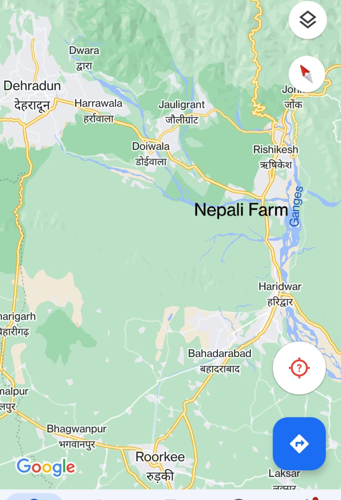
How to Reach Rishikesh from Haridwar via Nepali Farm -
If a trekker is coming from Roorkee or Haridwar via local transport and wants to reach Rishikesh then you can get a local vehicle but sometimes you might have to change the vehicle at Nepali farm which is a T-point or T-junction.
From here you can get local buses or local transport to reach Dehradun and Rishikesh. Rishikesh is approximately 7-10 km away from Nepali farm.
If you wish to go to Dehradun then take the left turn from the T point while coming from Haridwar and reach Dehradun via Doiwala.
Roorkee/Haridwar → Nepali farm(T-point) → Dehradun/Rishikesh
What is the best time to do the Kuari Pass trek?
KUARI PASS IN MARCH AND APRIL
If you want to see new greenery intermingled with snow, this is the best time to do the Kuari pass trek.
March and April signal the end of winter and the arrival of spring. During these months, the Pass is distinguished by melting remnant snow, vibrantly colored meadows, and trees that become rich emerald green. It also provides hikers with the invigorating scent of flowers, particularly Rhododendrons. In March, glimpses of white and pink cherry blossoms are also seen.
KUARI PASS IN MAY AND JUNE
If you want to experience solitude and peace, this is the best time to do the Kuari pass trek.
During the summer, the days get lighter, allowing visitors unobstructed vistas of the snow-covered mountains. During these months, the Gorson Bugyal develops a rich verdant green cover.
The meadows take on a bright golden tint as they are encircled by age-old evergreen trees. This walk is less busy during these months, so you may experience it in greater solitude and peace.
KAURI PASS IN SEPTEMBER, OCTOBER AND NOVEMBER
These post-monsoon months offer the greatest trekking opportunities in Kuari Pass trek.
After the monsoon season, the grasslands and woods spring to life and shimmer. The perfect Kuari pass weather throughout these months attracts a large number of hikers.
During these months, the pleasant weather patterns, as well as the stunningly clear and sharp vistas of the lofty Dronagiri and Nanda Devi peaks, are unrivaled.
Weather and temperature of Kuari Pass Trek
The most favorable temperature is observed in the summer months starting from April and continuing to mid-June because the temperature ranges between 18 to 24 degrees Celsius.
During the months of spring and autumn, the weather is pleasant, and clear skies are observed. Yet, during the night, the temperature of the Kuari Pass Trek can fall and is chilly.
In November, the daytime temperature is optimal and cool whereas the nights are a bit cold.
The winter temperature falls to the extreme of -8 degrees Celsius with the maximum temperature not more than 12 degrees Celsius.
In the Tali forest trail and the Lower Khullara region, the temperature might even drop to the extent of -15 degrees Celsius as the winter in the region is fierce in the months from December to February.
What is the Kuari Pass trek difficulty?
Kuari Pass trek is classified under the category of an easy-moderate trek. Therefore this is considered as the most ideal trek for a beginner.
It also offers its own sets of challenges, which include the high altitude, rocky terrains, and trail that involves a steep climb. One should, hence, be both physically fit and ideally equipped before undertaking the trek.
The trek starts at an altitude of 6,900 feet from Dhak which further reaches up to a maximum altitude of 12,763 feet above sea level which is encountered at the pass. The temperature variations and the weather conditions are also fierce which demands before-hand preparations.
The average trek duration experienced everyday forms an average of 4-5 hours except on the day involving the crossing of the pass when it takes an average of 8 hours. This short span of the Kuari pass trek is another factor that makes it favorable for beginners.
What is the distance of the Kuari pass trek?
Starting from the small town of Joshimath, the six day trek passes through thick forest covers with mixed vegetation of Oak, rhododendrons, and other coniferous trees. The trek distance for Kuari Pass trek is 33 km.
Major attractions of the Kuari Pass Trek
The major attractions include several regions of the Kuari pass trek that allow you to have a 360-degree view of the Himalayan peaks which undoubtedly form the heart of the trek. It offers the view of peaks from 7000 meters club including Trishul (7120m), Kamet (7756m), Nanda Devi (7817m), Chaukhamba (7128m), and the majestic twin peaks of Nanda Devi East (7434m).
Other prominent peaks that make their appearance include Mukut Parbat, Mana, Rishi Pahad, Changbang, Nanda Ghunti, Hathi Ghoda Parbat, Neelkanth, Dronagiri, and many such mountain tops.
The trek commences at Joshimath, which lies in the Chamoli district of the Himalayas. Another treasure that this Lord Curzon's trail beholds is the cultural treasure, the small remote hamlets that you will cross through on your way uphill. Moreover, Himalayan black bears and the paw prints of leopards are also sometimes sighted on the track uphill.
Another major highlight that makes Kuari Pass Trek a wonder is the ethereal setting of the campsites. Contrary to the popular belief that trekking is all about ascending and descending rush, the Kuari Pass trek compels you to pause. It offers you the campsite that makes you want to stay and adore the blessings of nature.
Whether it’s the Khullara campsite with Mt. Dronagiri as its stunning backdrop or any other campsite on the Kuari Pass Trek is truly awe-inspiring.
Best Time to Visit
The best time for this trek is during October to December, February to April when the weather is pleasant and the views are clear.
Trek Details
Start Point
Joshimath/Lower Auli
End Point
Joshimath/Lower Auli
Pickup Location
Rishikesh & Haridwar
Drop Location
Rishikesh & Haridwar
Health & Safety
- For any Himalayan Trek, Ideal BMI for a trekker should be 18.5 to 24.9
- To keep a check of this please calculate BMI here
- Below given Safety checks should be done to get prepared for any Himalayan Trek.
- Balance : As well said a balanced mind and body gives out best in every condition and that too works in Himalayan treks as well.
- Legs Strength : Body and Legs Strength is required to carry body weight as well as the backpack while trekking in uneven multi terrains. Generally, a good strength on legs works out good in any Trek. One can gain legs strength by doing simple Squats.
- Muscle Flexibility : While trekking in Trans Himalayan region with a flexible body one can easily achieve full range of movement and this can be really helpful for trekkers as well as trek leads. A good flexible will be an advantage while walking on trails, climbing and river crossing etc. Flexibility can be achieved by simple stretching, yoga etc.
- Cardiovascular Endurance : Cardiovascular endurance is defined as the ability of lungs and heart to transmit oxygen to the body muscles. All Himalayan treks are basically ascending descending the slopes and for this trekkers should be having a good cardiovascular endurance. Anyone planning for a Himalayan trek can attain this capacity by doing any cardio exercise like running, swimming, cycling etc.
Speak to our expert Trek Advisors to help you choose the right trek.
Have Questions About This Trek?
Send us your enquiry and we'll get back to you soon.
Trek
Kuari Pass Trek
Difficulty Level
Easy to Moderate
Ideal for Beginners.
Duration
6 Days / 5 Nights
Max Altitude
12,763 ft (3,890 m)
Base Camp
Joshimath/Lower Auli
Best Time to Visit
Dec to March
Best for a snow experience (Dec–Mar)
Have Questions?
Speak to our expert Trek Advisors to help you choose the right trek.